
The 2010 Kenyan constitution abolished the Provincial system of governance, and under it, the 47 counties that we know today in Kenya were born. Nyeri is a town and county located in central Kenya, with an estimated population of about 759,164 inhabitants, according to the 2019 census data. Nyeri County carries the official county code 019 and is one of the most historically and culturally significant counties in the Central region of Kenya.
The purpose of counties like Nyeri having so many wards and sub-counties is to facilitate easy delivery of services to the common Mwananchi (Ordinary Kenyans). The 8 sub-counties in Nyeri County are further divided into 30 wards, and these wards form the backbone of local governance and resource allocation across the county. This comprehensive guide will walk you through everything that you need to know about Nyeri County’s administrative structure.
Before diving in, it is important to understand the difference between Nyeri’s sub-counties and constituencies. Nyeri County has 8 administrative sub-counties but only 6 electoral constituencies, because some sub-counties share a single constituency. Below you will find a complete breakdown of every sub-county, its wards, the 6 constituencies, and 2019 population data for each sub-county.
About Nyeri County
Nyeri County was formed in 2010 when the new Kenyan constitution was promulgated. Still, its history can be traced back to 1902, when Nyeri Town was founded due to the British Colonial presence in the area. Today, Nyeri Town is the county headquarters of Nyeri County.

Nyeri County is about 150 km from Nairobi County and borders several counties, including Kirinyaga County to the east, Nyandarua to the west, Muranga to the south, Laikipia to the north, and Meru County to the northeast. It covers an area of 3,337 square kilometers.
Below is the Map of Nyeri County to help you understand the geographical structure of Nyeri:
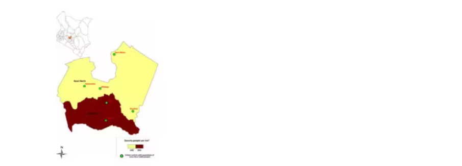
Nyeri County Map
Constituencies in Nyeri County
Nyeri County has 6 constituencies, which serve as the electoral units under which Members of Parliament are elected. These constituencies are distinct from the 8 administrative sub-counties, which are used for service delivery and local government administration purposes. Understanding this distinction helps residents know both who represents them in the National Assembly and which administrative offices serve their area.
The 6 constituencies in Nyeri County are:

- Kieni Constituency — covers Kieni East and Kieni West sub-counties
- Mathira Constituency — covers Mathira East and Mathira West sub-counties
- Nyeri Town Constituency — covers Nyeri Central sub-county
- Mukurweini Constituency — covers Mukurweini sub-county
- Tetu Constituency — covers Tetu sub-county
- Othaya Constituency — covers Othaya sub-county
Each constituency elects one Member of Parliament to the National Assembly. While the 6 constituencies handle electoral representation, the 8 sub-counties operate as the administrative arms of the county government, working to deliver health, agriculture, and infrastructure services to the people. The sub-counties of Kieni and Mathira are each split into two administrative sub-counties East and West to facilitate more efficient service delivery across their larger geographical areas.
Nyeri Sub-Counties and Their Wards
The County of Nyeri comprises 8 sub-counties and 30 wards. They are as follows:
1. Kieni East
- Gakawa
- Narumoru/Kiamathaga
- Kabaru
- Thegu
2. Kieni West
- Mugunda
- Gatarakwa
- Endarasha/Mwiyogo
- Mweiga
3. Mathira East
- Iriani
- Karatina
- Konyu
- Magutu
4. Mathira West
- Kirimukuyu
- Ruguru
5. Nyeri Central
- Kiganjo/Mathari
- Rware
- Gatitu/Muruguru
- Ruringu
- Kamakwa/Mukaro
6. Mukurweini
- Mukurwe-ini Central
- Mukurwe-ini West
- Rugi
- Gikondi
7. Tetu
- Dedan Kimathi
- Wamagana
- Aguthi-Gaaki
8. Othaya
- Chinga
- Iria-ini
- Karima
- Mahiga
Sub-County Population and Area
Understanding the size and population of each sub-county gives a fuller picture of how Nyeri County is distributed. The data below is drawn from the 2019 Kenya Population and Housing Census conducted by the Kenya National Bureau of Statistics (KNBS).
Nyeri Central is the most populous sub-county in Nyeri County, home to over 140,000 residents, while Kieni West covers the most expansive terrain, spanning over 517 square kilometres making it one of the more sparsely populated parts of the county relative to its land size. Mathira West is the least populated sub-county, with just under 60,000 residents spread across its two wards.
| Sub-County | 2019 Population | Approximate Area |
|---|---|---|
| Kieni East | 110,376 | 448.7 km² |
| Kieni West | 88,525 | 517.8 km² |
| Mathira East | 99,065 | ~131 km² |
| Mathira West | 59,895 | — |
| Nyeri Central | 140,338 | 167.6 km² |
| Mukurweini | 89,137 | 179.1 km² |
| Tetu | 80,453 | — |
| Othaya | 91,081 | 169.2 km² |
| Total | 759,164 | ~3,337 km² |
Frequently Asked Questions
How many sub-counties are in Nyeri County?
Nyeri County has 8 sub-counties: Kieni East, Kieni West, Mathira East, Mathira West, Nyeri Central, Mukurweini, Tetu, and Othaya. These are administrative units used for service delivery by the county government.
How many wards does Nyeri County have?
Nyeri County has a total of 30 wards, distributed across its 8 sub-counties. Nyeri Central has the most wards (5), while Mathira West and Tetu have the fewest at 2 and 3 wards respectively.
What are the constituencies in Nyeri County?
Nyeri County has 6 constituencies: Kieni, Mathira, Nyeri Town, Mukurweini, Tetu, and Othaya. Each constituency elects one Member of Parliament to Kenya’s National Assembly.
What counties border Nyeri County?
Nyeri County borders five counties: Kirinyaga to the east, Nyandarua to the west, Murang’a to the south, Laikipia to the north, and Meru to the northeast.


